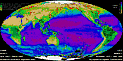
Explore the World with SeaWiFS at 4 kilometer resolution
 Most Recent SeaWiFS Images
Explore the World with SeaWiFS at 4 kilometer resolution
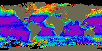 Nimbus-7 CZCS Global and Regional Data Sets and Documentation
 OCTS imagery of the Gulf of Maine
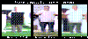
 SeaStar and SeaWiFS Construction Photo Archive
![]() Photograph of the Coastal Zone Color Scanner
Photograph of the Coastal Zone Color Scanner
 Earth Observation Movie Studio
 Nimbus-7 Total Ozone Mapping Spectrometer (TOMS) images (1979-1992)
![]() Surface Solar Irradiance from NASA/Goddard Institute for Space Studies
Surface Solar Irradiance from NASA/Goddard Institute for Space Studies
 Global Sea Surface Temperature maps
![]() VRML Topographic Map Generator by Dave Pape
VRML Topographic Map Generator by Dave Pape
![]() Ocean Color from Space folder
from the Goddard DAAC
Ocean Color from Space folder
from the Goddard DAAC
![]()